
Directions
High Ledge is located in
Connecticut about 8 miles from the Rhode Island border not far from
Lantern Hill. From Rhode Island take Interstate 95 south to exit 92
(North Stonington). On the exit stay straight for about a mile until
you hit a traffic light. At the light take a right on to Route 2 west.
After a couple of miles, you will go straight through a traffic circle.
At the next traffic light take a right across
from a fire station onto Rocky Hollow Road. This brings you
to Main Street in North Stonington village. Bear
right on
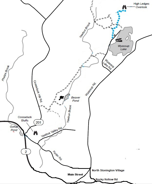
Wyassup Road. Follow this for about 3 miles. Look for a small brown
boat launch sign on the left. This is Wyassup
Lake Road. Follow this to the boat launch (0.8 miles).
About fifty yards after the boat launch you will see a road/trail on
the left with a metal gate on it. Park on the side of the road
here
but do not block the fire road. There is only room here for three
vehicles so carpool and park across from the boat launch if necessary.
This is the Narragansett Trail on
state land in the Pachaug State Forest. Follow this road/trail. When
the road takes a sharp bend to the left follow the blue dot trail that
is straight ahead. Follow this for about 1/2 mile, past a gas line cut
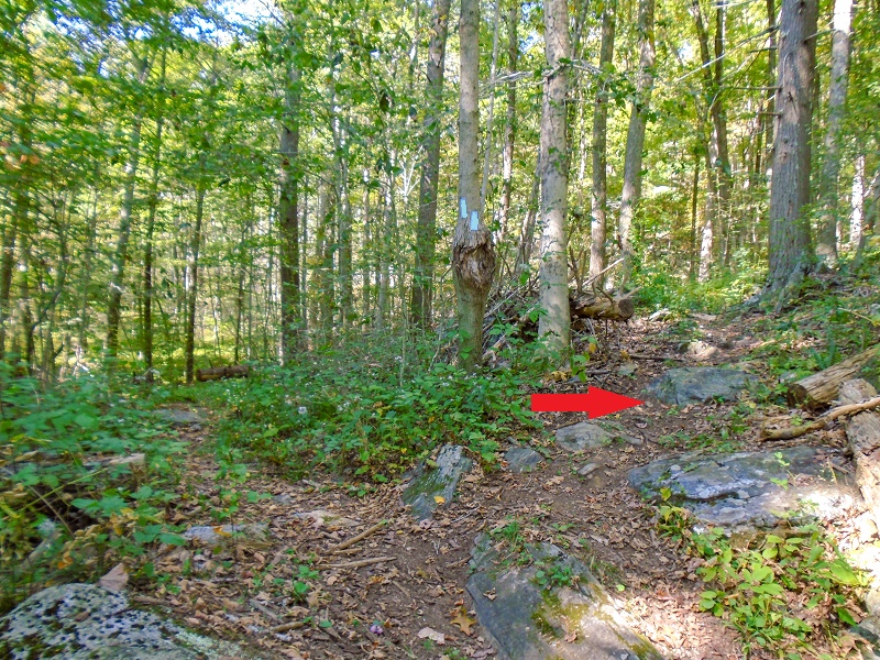
until the trail splits. It is marked by a blue trail split marker
(photo below). Take
the trail to the right up a small hill
and down a swampy
valley. You will see the cliff from there.
.
 |
 |
This cliff was infrequently
climbed back in the 1990s and early 2000s. It was revisited lately and
new routes were cleaned and
put up on the unclimbed left side. The cliff ranges from 30 to 65 feet
in
height. The rock offers juggy, vertical to overhanging routes.
There is
lots of loose rock so beware. Most of the better quality and steeper
routes are
on the right side of the cliff. It is where Tough Schist, a frequently done
5.10, is located. Some harder routes can be established here. There are a
few crack systems on the left end that look like they would provide practice
leading but the rock quality here is not good.
Pistol Whip, the 5.8+ roof on
the main cliff was led in 2005 (first known ascent) but the rock is schisty and
the gear placement at the crux is at your feet, so it is a potential ankle
breaker. Most routes here were top-roped. Due to the lack of climbing and
the quality of the rock many routes are now fully bolted, and the crag should
become more popular. The names of a couple of the routes (Pistol Whip and Trigger) were unnamed and names were made up for reference in the Rock Climbing Connecticut guidebook. In the Known Route History below, all First Ascents (FA) refer
to a route that has been led ground-up no falls and is improbable that it was previously
led. Otherwise, it is noted as a top-rope (TR) ascent. If there is doubt that
it is a FA then FRA (First Recorded Ascent) is used. A system denoting
quality of one to three stars is used.
Many climbers assume that the bolts are
someone else’s responsibility. Your
safety
is ALWAYS your
responsibility when you are climbing outside. Climbing is inherently
dangerous.
Routes
from Left to Right
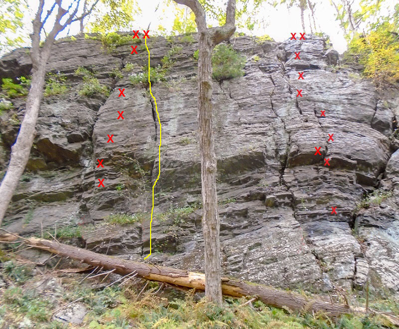
Bait and Schist 5.8. Rolodex 5.8. Schist Eating Grin 5.8. Schist andd Giggles 5.6. Fulla
Schist 5.7-
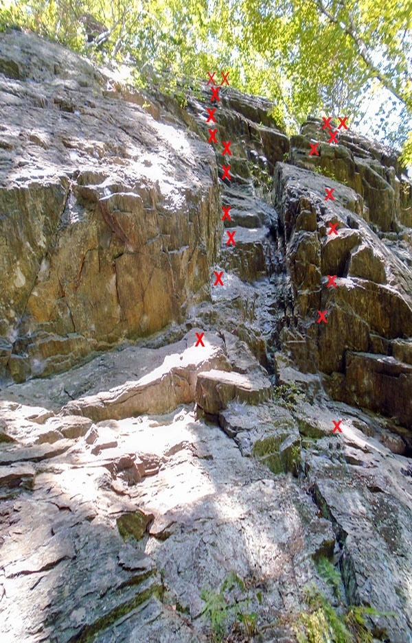 Trench Run** 5.7. Interceptor 5.9+
|
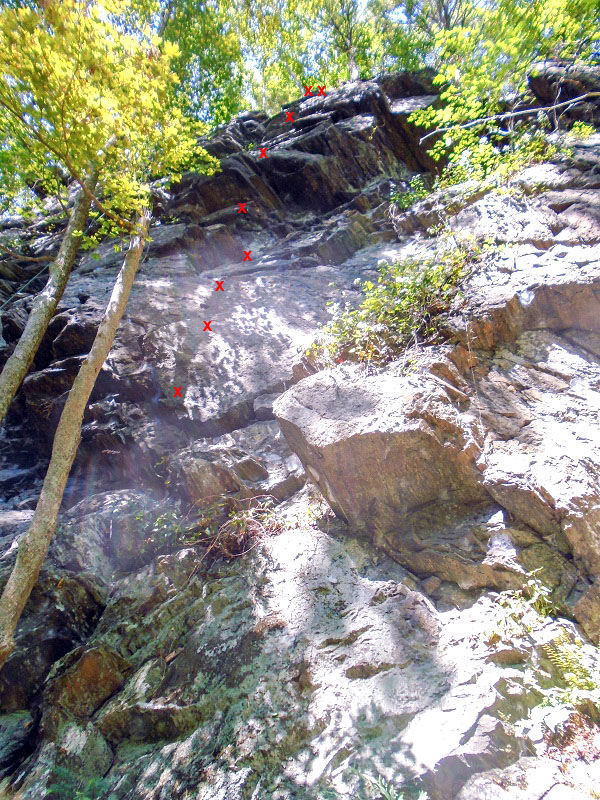 Schist Happens** 5.7
|
|
 Tough Schist***, 5.10. La Dura Schist 5.12a |
Known Route
History
Bait and Schist 5.8, FA Jay Adams 2024
Rolodex 5.8, FA Jay Adams 2024
Schist Eating Grin
5.8, FA Jay Adams 2024
Schist and Giggles 5.6, FA Jay Adams 2024
Fulla Schist
5.7-, FA Brian Phillips 2024
Trench
Run
5.7, FA Jay Adams 2024
Interceptor 5.9+, FA Jay Adams 2024, Shares the last bolt and anchors with Schist Happens.
Schist
Happens
5.7, FA Brian Phillips 2024
Pistol Whip
5.8+, FRA Brian Phillips 2004, Led this trad in 2004, probably top-roped
before that,
possibly led. Trad pro is at your feet and the rock is not good at the
roof. A fall could result in a broken leg.
Trigger
5.6, FA Brian Phillips 2024, Top-roped many times before. Arete that
can be started a variety of ways depending on how hard you want to make
it. Shares first bolt with Schist Faced.
Schist Faced
5.6, FA Brian Phillips 2004, Possibly top-roped before that.
Roller Blade
5.10+, TR Ken Nichols 1999. Ascends the roofs on the left toppng out on
the pointed blade of rock.
Tough
Schist
5.10, FA Brian Phillips 2004, 7 bolts to anchor. Possibly top-roped
before that.
La
Dura Schist 5.12a, TR Brian Phillips 2024, Top rope. Has anchor bolts
and a bolt with a leave-it biner for a directional. Overhanging fragile
rock.